Pāveh night lights from space
Night Light of Pāveh (Kermānshāh) from space (Iran) Src. Average luminocity for 10x10km area is 18.9615% and for 50x50km: 2.4053%.
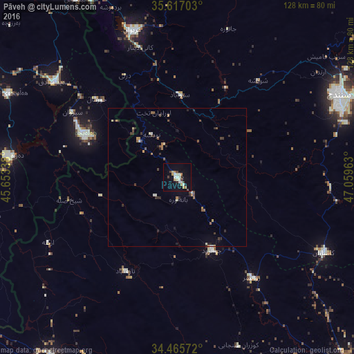
Analysis of Pāveh night lights 2016
Square area 10x10 km:
 1.05%
1.05%90-99
5.94%80-89
1.92%70-79
2.62%60-69
1.75%50-59
0.35%40-49
3.5%30-39
1.05%20-29
0.7%10-19
12.59%0-9
68.53%Square area 50x50 km:
0.06%90-99
0.46%80-89
0.2%70-79
0.32%60-69
0.27%50-59
0.33%40-49
0.53%30-39
0.44%20-29
0.5%10-19
0.75%0-9
96.15%Clear (daylight) street map image can be seen on geolist.org.
Map coordinates:
35° 37' 1.3" North, 45° 39' 12.2" East
35° 2' 36.2" North, 46° 21' 23.4" East
34° 27' 56.6" North, 47° 3' 34.7" East
Some cities around Pāveh sort by population:
• Kahrīz
97.3 km =60.5 mi,  138°
138°
• Sanandaj
65.7 km =40.8 mi,  62°
62°
• Marīvān
55.1 km =34.2 mi,  343°
343°
• Kāmyārān
59.5 km =37 mi,  117°
117°
• Ḩalabjah, IQ
36.9 km =22.9 mi,  293°
293°
• Sarpol-e Z̄ahāb
78.9 km =49 mi,  214°
214°
• Javānrūd
31.2 km =19.4 mi,  151°
151°
• Baynjiwayn, IQ
74.1 km =46 mi,  330°
330°
121240 (p: 17,779)
Sources (retrieved 2019-11-25):
» Earth at Night: Flat Maps 2012, 2016