Mehrān night lights from space
Night Light of Mehrān (Ilam Province) from space (Iran) Src. Average luminocity for 10x10km area is 38.304% and for 50x50km: 15.8531%.
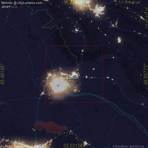
Analysis of Mehrān night lights 2016
Square area 10x10 km:
 2.75%
2.75%90-99
10.44%80-89
2.38%70-79
1.83%60-69
2.56%50-59
3.11%40-49
16.3%30-39
11.36%20-29
15.38%10-19
26.37%0-9
7.51%Square area 50x50 km:
0.82%90-99
5%80-89
2.05%70-79
0.54%60-69
1.13%50-59
3.59%40-49
4.88%30-39
3.86%20-29
3.75%10-19
4.4%0-9
69.99%Clear (daylight) street map image can be seen on geolist.org.
Map coordinates:
33° 42' 32.7" North, 45° 27' 41.3" East
33° 7' 19.9" North, 46° 9' 52.6" East
32° 31' 52.9" North, 46° 52' 3.8" East
Some cities around Mehrān sort by population:
• Al Kūt, IQ
75.1 km =46.7 mi,  205°
205°
• Īlām
62.1 km =38.6 mi,  22°
22°
• Al Ḩayy, IQ
106 km =65.9 mi,  186°
186°
• Dehlorān
113.5 km =70.5 mi,  114°
114°
• Al ‘Azīzīyah, IQ
105.3 km =65.4 mi,  257°
257°
• Mandalī, IQ
89.7 km =55.7 mi,  320°
320°
• Darreh Shahr
113.2 km =70.3 mi,  88°
88°
• ‘Alī al Gharbī, IQ
88.2 km =54.8 mi,  146°
146°
124291 (p: 11,831)
Sources (retrieved 2019-11-25):
» Earth at Night: Flat Maps 2012, 2016