‘Alī al Gharbī night lights from space
Night Light of ‘Alī al Gharbī (Maysan) from space (Iraq) Src. Average luminocity for 10x10km area is 11.1777% and for 50x50km: 0.5524%.
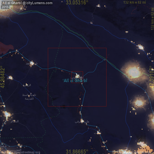
Analysis of ‘Alī al Gharbī night lights 2016
Square area 10x10 km:
 0.55%
0.55%90-99
2.38%80-89
0.55%70-79
2.01%60-69
1.83%50-59
1.47%40-49
0.92%30-39
2.75%20-29
3.66%10-19
0.73%0-9
83.15%Square area 50x50 km:
0.02%90-99
0.09%80-89
0.02%70-79
0.11%60-69
0.1%50-59
0.09%40-49
0.04%30-39
0.15%20-29
0.19%10-19
0.06%0-9
99.14%Clear (daylight) street map image can be seen on geolist.org.
Map coordinates:
33° 3' 11.4" North, 45° 59' 5.4" East
32° 27' 42.7" North, 46° 41' 16.6" East
31° 51' 59.9" North, 47° 23' 27.9" East
Some cities around ‘Alī al Gharbī sort by population:
• Al ‘Amārah
81.8 km =50.8 mi,  148°
148°
• Al Kūt
81.8 km =50.8 mi,  273°
273°
• Ash Shaţrah
126.8 km =78.8 mi,  202°
202°
• Al Ḩayy
68.5 km =42.6 mi,  242°
242°
• Dehlorān, IR
60.2 km =37.4 mi,  64°
64°
• Darreh Shahr, IR
99.7 km =62 mi,  40°
40°
• Ābdānān, IR
90.4 km =56.2 mi,  49°
49°
• Mehrān, IR
88.2 km =54.8 mi,  326°
326°
99306 (p: 19,711)
Sources (retrieved 2019-11-25):
» Earth at Night: Flat Maps 2012, 2016