Villiers night lights from space
Night Light of Villiers (Orange Free State) from space (South Africa) Src. Average luminocity for 10x10km area is 9.3214% and for 50x50km: 0.7345%.
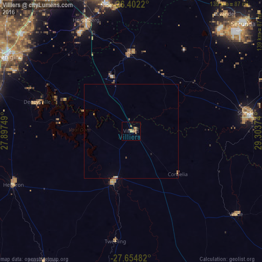
Analysis of Villiers night lights 2016
Square area 10x10 km:
 0%
0%90-99
0.2%80-89
2.18%70-79
2.58%60-69
2.98%50-59
1.59%40-49
0.79%30-39
0.6%20-29
0.99%10-19
1.59%0-9
86.51%Square area 50x50 km:
0.01%90-99
0.09%80-89
0.08%70-79
0.19%60-69
0.17%50-59
0.08%40-49
0.07%30-39
0.08%20-29
0.11%10-19
0.13%0-9
98.98%Clear (daylight) street map image can be seen on geolist.org.
Map coordinates:
26° 24' 7.9" South, 27° 53' 51" East
27° 1' 48.9" South, 28° 36' 2.2" East
27° 39' 17.4" South, 29° 18' 13.5" East
Some cities around Villiers sort by population:
• eMbalenhle
72.1 km =44.8 mi,  39°
39°
• Nigel
67.7 km =42.1 mi,  349°
349°
• Standerton
64.4 km =40 mi,  80°
80°
• Heidelberg
63.2 km =39.3 mi,  337°
337°
• Heilbron
68.3 km =42.4 mi,  245°
245°
• Balfour
40.8 km =25.4 mi,  358°
358°
• Vrede
71.1 km =44.2 mi,  128°
128°
• Deneysville
52.3 km =32.5 mi,  287°
287°
943937 (p: 11,240)
Sources (retrieved 2019-11-25):
» Earth at Night: Flat Maps 2012, 2016