Deneysville night lights from space
Night Light of Deneysville (Orange Free State) from space (South Africa) Src. Average luminocity for 10x10km area is 14.2599% and for 50x50km: 8.2655%.
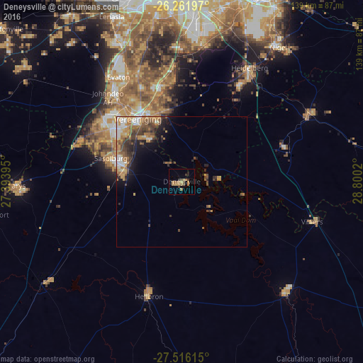
Analysis of Deneysville night lights 2016
Square area 10x10 km:
 0%
0%90-99
0%80-89
0.6%70-79
7.14%60-69
3.37%50-59
2.98%40-49
1.19%30-39
2.18%20-29
0.6%10-19
0.99%0-9
80.95%Square area 50x50 km:
0.97%90-99
1.02%80-89
0.57%70-79
1.99%60-69
1.63%50-59
1.46%40-49
1.62%30-39
1.49%20-29
1.55%10-19
2.95%0-9
84.75%Clear (daylight) street map image can be seen on geolist.org.
Map coordinates:
26° 15' 43.1" South, 27° 23' 38.2" East
26° 53' 26.9" South, 28° 5' 49.5" East
27° 30' 58.1" South, 28° 48' 0.7" East
Some cities around Deneysville sort by population:
• Vereeniging
29.6 km =18.4 mi,  324°
324°
• Vanderbijlpark
32.5 km =20.2 mi,  307°
307°
• Sasolburg
29.1 km =18.1 mi,  287°
287°
• Heidelberg
50.2 km =31.2 mi,  31°
31°
• Heilbron
45.2 km =28.1 mi,  196°
196°
• Balfour
55.1 km =34.2 mi,  62°
62°
• Villiers
52.3 km =32.5 mi,  107°
107°
• Orange Farm
50.8 km =31.6 mi,  333°
333°
1010962 (p: 12,397)
Sources (retrieved 2019-11-25):
» Earth at Night: Flat Maps 2012, 2016