Stutterheim night lights from space
Night Light of Stutterheim (Eastern Cape) from space (South Africa) Src. Average luminocity for 10x10km area is 9.8986% and for 50x50km: 0.5178%.
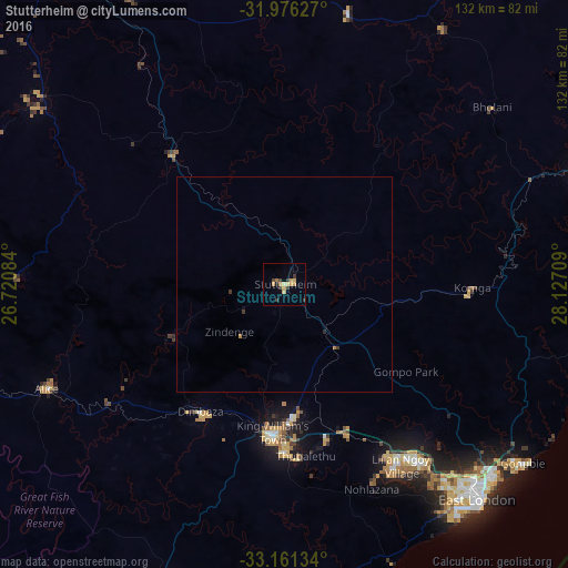

Analysis of Stutterheim night lights 2016
Square area 10x10 km:
 0%
0%90-99
0%80-89
2.97%70-79
3.5%60-69
1.22%50-59
0%40-49
1.4%30-39
4.2%20-29
0%10-19
0.7%0-9
86.01%Square area 50x50 km:
0%90-99
0%80-89
0.12%70-79
0.17%60-69
0.08%50-59
0%40-49
0.06%30-39
0.26%20-29
0.03%10-19
0.04%0-9
99.23%Clear (daylight) street map image can be seen on geolist.org.
Map coordinates:
31° 58' 34.6" South, 26° 43' 15" East
32° 34' 14.7" South, 27° 25' 26.3" East
33° 9' 40.8" South, 28° 7' 37.5" East
Some cities around Stutterheim sort by population:
• East London
67.2 km =41.8 mi,  137°
137°
• Bhisho
30.8 km =19.1 mi,  176°
176°
• Fort Beaufort
77.4 km =48.1 mi,  252°
252°
• Butterworth
73.1 km =45.4 mi,  68°
68°
• Queensdale
88.4 km =54.9 mi,  331°
331°
• Whittlesea
71.4 km =44.4 mi,  307°
307°
• Ilinge
75.1 km =46.7 mi, 331°
• Alice
60.2 km =37.4 mi, 246°
951650 (p: 35,510)
Sources (retrieved 2019-11-25):
» Earth at Night: Flat Maps 2012, 2016