Alice night lights from space
Night Light of Alice (Eastern Cape) from space (South Africa) Src. Average luminocity for 10x10km area is 8.1906% and for 50x50km: 1.1193%.
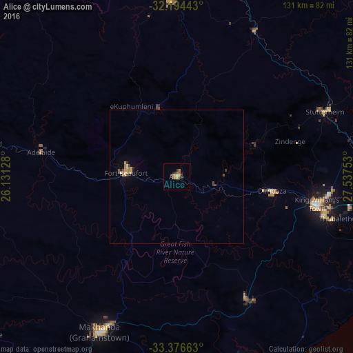
Analysis of Alice night lights 2016
Square area 10x10 km:
 0.52%
0.52%90-99
0.17%80-89
0.87%70-79
2.45%60-69
2.27%50-59
0.7%40-49
1.05%30-39
1.92%20-29
1.4%10-19
1.75%0-9
86.89%Square area 50x50 km:
0.06%90-99
0.09%80-89
0.12%70-79
0.28%60-69
0.27%50-59
0.07%40-49
0.22%30-39
0.17%20-29
0.08%10-19
0.27%0-9
98.37%Clear (daylight) street map image can be seen on geolist.org.
Map coordinates:
32° 11' 39.9" South, 26° 7' 52.6" East
32° 47' 15" South, 26° 50' 3.8" East
33° 22' 35.9" South, 27° 32' 15.1" East
Some cities around Alice sort by population:
• Bhisho
57.2 km =35.5 mi,  96°
96°
• Grahamstown
64 km =39.8 mi,  206°
206°
• Fort Beaufort
18.8 km =11.7 mi,  274°
274°
• Stutterheim
60.2 km =37.4 mi,  66°
66°
• Port Alfred
88.9 km =55.2 mi,  177°
177°
• Adelaide
51.2 km =31.8 mi,  280°
280°
• Whittlesea
68 km =42.3 mi,  359°
359°
• Ilinge
92.2 km =57.3 mi,  12°
12°
1023332 (p: 9,788)
Sources (retrieved 2019-11-25):
» Earth at Night: Flat Maps 2012, 2016