George night lights from space
Night Light of George (Western Cape) from space (South Africa) Src. Average luminocity for 10x10km area is 47.8112% and for 50x50km: 3.257%.
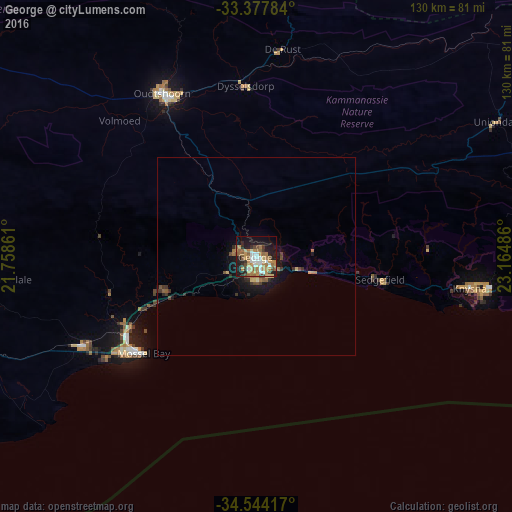
Analysis of George night lights 2016
Square area 10x10 km:
 7.34%
7.34%90-99
7.34%80-89
5.07%70-79
10.49%60-69
11.01%50-59
8.04%40-49
4.55%30-39
4.02%20-29
10.14%10-19
27.27%0-9
4.72%Square area 50x50 km:
0.3%90-99
0.31%80-89
0.33%70-79
0.54%60-69
0.68%50-59
0.58%40-49
0.39%30-39
0.51%20-29
0.68%10-19
2.76%0-9
92.89%Clear (daylight) street map image can be seen on geolist.org.
Map coordinates:
33° 22' 40.2" South, 21° 45' 31" East
33° 57' 46.8" South, 22° 27' 42.2" East
34° 32' 39" South, 23° 9' 53.5" East
Some cities around George sort by population:
• Knysna
54.6 km =33.9 mi,  98°
98°
• Oudtshoorn
47 km =29.2 mi,  328°
328°
• Mossel Bay
38 km =23.6 mi,  229°
229°
• Plettenberg Bay
84.5 km =52.5 mi, 96°
• Riversdale
111.9 km =69.5 mi,  262°
262°
• Prince Albert
91.4 km =56.8 mi, 333°
• Willowmore
120.9 km =75.1 mi,  51°
51°
• Albertina
85.6 km =53.2 mi,  251°
251°
1002145 (p: 12,345)
Sources (retrieved 2019-11-25):
» Earth at Night: Flat Maps 2012, 2016