Plettenberg Bay night lights from space
Night Light of Plettenberg Bay (Western Cape) from space (South Africa) Src. Average luminocity for 10x10km area is 13.2727% and for 50x50km: 0.932%.
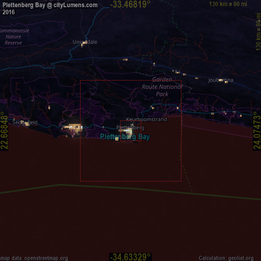
Analysis of Plettenberg Bay night lights 2016
Square area 10x10 km:
 0.7%
0.7%90-99
1.57%80-89
1.75%70-79
1.22%60-69
1.57%50-59
4.2%40-49
2.62%30-39
2.1%20-29
1.75%10-19
1.75%0-9
80.77%Square area 50x50 km:
0.05%90-99
0.09%80-89
0.09%70-79
0.16%60-69
0.17%50-59
0.2%40-49
0.11%30-39
0.2%20-29
0.11%10-19
0.11%0-9
98.73%Clear (daylight) street map image can be seen on geolist.org.
Map coordinates:
33° 28' 5.5" South, 22° 40' 6.5" East
34° 3' 9.9" South, 23° 22' 17.8" East
34° 37' 59.8" South, 24° 4' 29" East
Some cities around Plettenberg Bay sort by population:
• Knysna
30 km =18.6 mi,  273°
273°
• Oudtshoorn
119.4 km =74.2 mi,  294°
294°
• Mossel Bay
113.7 km =70.6 mi,  262°
262°
• Kruisfontein
125.4 km =77.9 mi,  87°
87°
• Prince Albert
154.8 km =96.2 mi,  306°
306°
• George
84.5 km =52.5 mi,  276°
276°
• Willowmore
85.2 km =52.9 mi,  7°
7°
• Albertina
165.8 km =103 mi, 264°
964712 (p: 19,445)
Sources (retrieved 2019-11-25):
» Earth at Night: Flat Maps 2012, 2016