Chivacoa night lights from space
Night Light of Chivacoa (Yaracuy) from space (Venezuela) Src. Average luminocity for 10x10km area is 18.1798% and for 50x50km: 6.4735%.
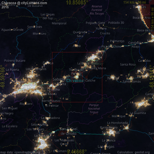

Analysis of Chivacoa night lights 2016
Square area 10x10 km:
 0%
0%90-99
2.07%80-89
1.65%70-79
4.34%60-69
5.79%50-59
3.31%40-49
1.03%30-39
2.48%20-29
1.65%10-19
6.82%0-9
70.87%Square area 50x50 km:
0.54%90-99
0.63%80-89
0.35%70-79
0.89%60-69
1.49%50-59
1.09%40-49
0.79%30-39
1.45%20-29
1.37%10-19
5.53%0-9
85.87%Clear (daylight) street map image can be seen on geolist.org.
Map coordinates:
10° 51' 3.1" North, 69° 35' 51.6" West
10° 9' 34.2" North, 68° 53' 40.3" West
9° 28' 0" North, 68° 11' 29.1" West
Some cities around Chivacoa sort by population:
• Barquisimeto
51.7 km =32.1 mi,  258°
258°
• Yaritagua
26.6 km =16.5 mi,  250°
250°
• Tinaquillo
69.9 km =43.4 mi,  112°
112°
• San Carlos
65.1 km =40.5 mi,  148°
148°
• San Felipe
26.1 km =16.2 mi,  39°
39°
• Araure
74.5 km =46.3 mi,  210°
210°
• Los Rastrojos
40.8 km =25.4 mi, 248°
• Nirgua
36.1 km =22.4 mi,  91°
91°
3645671 (p: 45,904)
Sources (retrieved 2019-11-25):
» Earth at Night: Flat Maps 2012, 2016