Willoughby Hills night lights from space
Night Light of Willoughby Hills (Ohio) from space (United States) Src. Average luminocity for 10x10km area is 62.3701% and for 50x50km: 35.9841%.
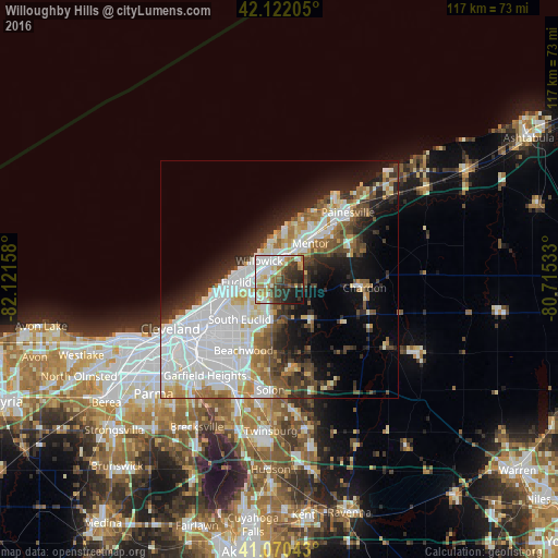
Analysis of Willoughby Hills night lights 2016
Square area 10x10 km:
 15.42%
90-99
17.05%80-89
6.82%70-79
4.71%60-69
10.06%50-59
4.71%40-49
5.68%30-39
16.07%20-29
10.88%10-19
8.6%0-9
0%Square area 50x50 km:
12.49%90-99
8.55%80-89
2.73%70-79
2.82%60-69
3.5%50-59
3.14%40-49
3.76%30-39
4%20-29
6.46%10-19
9.89%0-9
42.66%Clear (daylight) street map image can be seen on geolist.org.
Map coordinates:
42° 7' 19.4" North, 82° 7' 17.7" West
41° 35' 54.2" North, 81° 25' 6.4" West
41° 4' 13.5" North, 80° 42' 55.2" West
Some cities around Willoughby Hills sort by population:
• Euclid
9 km =5.6 mi,  266°
266°
• Mentor
10 km =6.2 mi,  41°
41°
• Mayfield Heights
9.4 km =5.8 mi,  200°
200°
• Eastlake
6.7 km =4.2 mi,  336°
336°
• Wickliffe
3 km =1.9 mi,  284°
284°
• Richmond Heights
9.2 km =5.7 mi,  236°
236°
• Highland Heights
7.2 km =4.5 mi,  224°
224°
• Kirtland
5.8 km =3.6 mi,  54°
54°
5176942 (p: 9,382)
Sources (retrieved 2019-11-25):
» Earth at Night: Flat Maps 2012, 2016