Mayfield Heights night lights from space
Night Light of Mayfield Heights (Ohio) from space (United States) Src. Average luminocity for 10x10km area is 73.3605% and for 50x50km: 44.6548%.
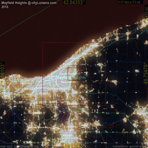
Analysis of Mayfield Heights night lights 2016
Square area 10x10 km:
 18.37%
90-99
27.72%80-89
8.84%70-79
4.42%60-69
6.12%50-59
9.69%40-49
8.5%30-39
6.29%20-29
9.01%10-19
1.02%0-9
0%Square area 50x50 km:
14.44%90-99
10.19%80-89
3.61%70-79
4.03%60-69
6.17%50-59
5.36%40-49
4.96%30-39
4.78%20-29
6.46%10-19
8.71%0-9
31.29%Clear (daylight) street map image can be seen on geolist.org.
Map coordinates:
42° 2' 36.7" North, 82° 9' 39.7" West
41° 31' 9.2" North, 81° 27' 28.4" West
40° 59' 26.3" North, 80° 45' 17.2" West
Some cities around Mayfield Heights sort by population:
• Cleveland Heights
8.2 km =5.1 mi,  270°
270°
• South Euclid
5.1 km =3.2 mi, 274°
• Lyndhurst
2.6 km =1.6 mi, 272°
• University Heights
7 km =4.3 mi,  250°
250°
• Beachwood
7.4 km =4.6 mi,  214°
214°
• Richmond Heights
5.7 km =3.5 mi,  310°
310°
• Highland Heights
4 km =2.5 mi,  334°
334°
• Pepper Pike
4.6 km =2.9 mi,  186°
186°
5162188 (p: 18,840)
Sources (retrieved 2019-11-25):
» Earth at Night: Flat Maps 2012, 2016