Richmond Heights night lights from space
Night Light of Richmond Heights (Ohio) from space (United States) Src. Average luminocity for 10x10km area is 94.2653% and for 50x50km: 43.8662%.
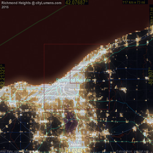
Analysis of Richmond Heights night lights 2016
Square area 10x10 km:
 42.69%
90-99
36.73%80-89
11.22%70-79
5.61%60-69
3.57%50-59
0%40-49
0.17%30-39
0%20-29
0%10-19
0%0-9
0%Square area 50x50 km:
15.63%90-99
10.04%80-89
3.56%70-79
3.95%60-69
5.71%50-59
4.38%40-49
3.99%30-39
4.18%20-29
6.24%10-19
8.14%0-9
34.16%Clear (daylight) street map image can be seen on geolist.org.
Map coordinates:
42° 4' 36.7" North, 82° 12' 47.7" West
41° 33' 10.2" North, 81° 30' 36.4" West
41° 1' 28.2" North, 80° 48' 25.2" West
Some cities around Richmond Heights sort by population:
• Euclid
4.7 km =2.9 mi,  342°
342°
• Cleveland Heights
5.3 km =3.3 mi,  226°
226°
• Collinwood
5 km =3.1 mi,  277°
277°
• South Euclid
3.4 km =2.1 mi,  191°
191°
• Mayfield Heights
5.7 km =3.5 mi,  130°
130°
• East Cleveland
6.1 km =3.8 mi,  249°
249°
• Lyndhurst
4.1 km =2.5 mi,  153°
153°
• Highland Heights
2.6 km =1.6 mi,  92°
92°
5168063 (p: 10,469)
Sources (retrieved 2019-11-25):
» Earth at Night: Flat Maps 2012, 2016