Highland Heights night lights from space
Night Light of Highland Heights (Ohio) from space (United States) Src. Average luminocity for 10x10km area is 87.4575% and for 50x50km: 42.9942%.
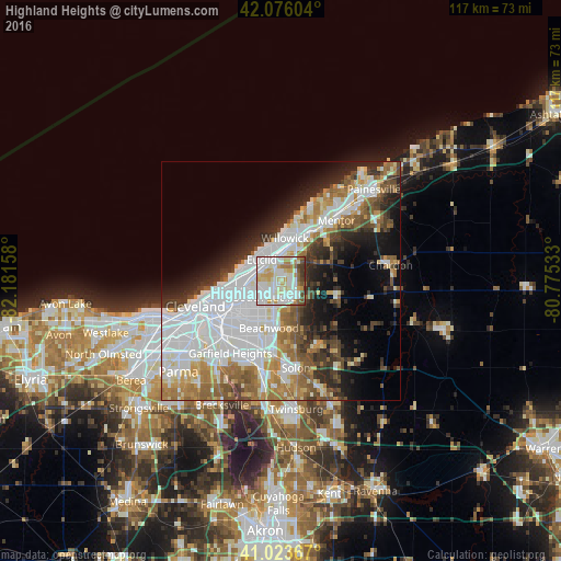
Analysis of Highland Heights night lights 2016
Square area 10x10 km:
 30.27%
90-99
33.16%80-89
12.76%70-79
7.82%60-69
6.12%50-59
4.08%40-49
3.91%30-39
1.87%20-29
0%10-19
0%0-9
0%Square area 50x50 km:
14.64%90-99
9.79%80-89
3.52%70-79
3.8%60-69
5.77%50-59
4.61%40-49
4.25%30-39
4.28%20-29
6.47%10-19
8.82%0-9
34.05%Clear (daylight) street map image can be seen on geolist.org.
Map coordinates:
42° 4' 33.7" North, 82° 10' 53.7" West
41° 33' 7.2" North, 81° 28' 42.4" West
41° 1' 25.2" North, 80° 46' 31.2" West
Some cities around Highland Heights sort by population:
• Euclid
6.1 km =3.8 mi,  318°
318°
• Cleveland Heights
7.4 km =4.6 mi,  241°
241°
• South Euclid
4.6 km =2.9 mi,  226°
226°
• Mayfield Heights
4 km =2.5 mi,  154°
154°
• Lyndhurst
3.7 km =2.3 mi,  193°
193°
• Wickliffe
6.3 km =3.9 mi,  19°
19°
• Richmond Heights
2.6 km =1.6 mi,  272°
272°
• Willoughby Hills
7.2 km =4.5 mi,  44°
44°
5157497 (p: 8,396)
Sources (retrieved 2019-11-25):
» Earth at Night: Flat Maps 2012, 2016