Euclid night lights from space
Night Light of Euclid (Ohio) from space (United States) Src. Average luminocity for 10x10km area is 77.0244% and for 50x50km: 39.0231%.
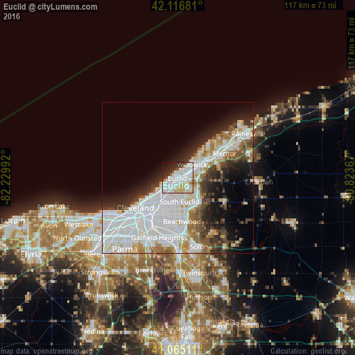

Analysis of Euclid night lights 2016
Square area 10x10 km:
 29.71%
90-99
30.36%80-89
6.49%70-79
4.71%60-69
1.79%50-59
1.62%40-49
1.95%30-39
6.98%20-29
9.74%10-19
5.84%0-9
0.81%Square area 50x50 km:
16%90-99
9.56%80-89
2.76%70-79
2.71%60-69
3.19%50-59
2.78%40-49
3.22%30-39
3.77%20-29
5.78%10-19
7.86%0-9
42.37%Clear (daylight) street map image can be seen on geolist.org.
Map coordinates:
42° 7' 0.5" North, 82° 13' 47.7" West
41° 35' 35.2" North, 81° 31' 36.4" West
41° 3' 54.4" North, 80° 49' 25.2" West
Some cities around Euclid sort by population:
• Cleveland Heights
8.5 km =5.3 mi,  196°
196°
• Collinwood
5.2 km =3.2 mi,  222°
222°
• South Euclid
7.8 km =4.8 mi,  174°
174°
• East Cleveland
8 km =5 mi,  213°
213°
• Willowick
6.6 km =4.1 mi,  47°
47°
• Wickliffe
6.2 km =3.9 mi,  77°
77°
• Richmond Heights
4.7 km =2.9 mi,  162°
162°
• Highland Heights
6.1 km =3.8 mi,  138°
138°
5153420 (p: 47,676)
Sources (retrieved 2019-11-25):
» Earth at Night: Flat Maps 2012, 2016