Kirtland night lights from space
Night Light of Kirtland (Ohio) from space (United States) Src. Average luminocity for 10x10km area is 56.9481% and for 50x50km: 30.5374%.
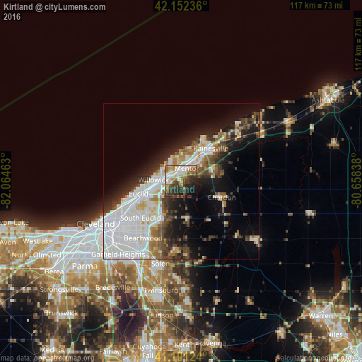
Analysis of Kirtland night lights 2016
Square area 10x10 km:
 11.36%
90-99
12.5%80-89
5.52%70-79
7.63%60-69
10.39%50-59
5.84%40-49
7.95%30-39
14.45%20-29
14.12%10-19
7.79%0-9
2.44%Square area 50x50 km:
10.19%90-99
6.88%80-89
2.32%70-79
2.2%60-69
2.75%50-59
2.93%40-49
3.47%30-39
3.61%20-29
6.15%10-19
10.47%0-9
49.05%Clear (daylight) street map image can be seen on geolist.org.
Map coordinates:
42° 9' 8.5" North, 82° 3' 52.7" West
41° 37' 44.2" North, 81° 21' 41.4" West
41° 6' 4.5" North, 80° 39' 30.2" West
Some cities around Kirtland sort by population:
• Mentor
4.5 km =2.8 mi,  23°
23°
• Willoughby
3.9 km =2.4 mi,  287°
287°
• Eastlake
7.9 km =4.9 mi, 290°
• Willowick
8.9 km =5.5 mi,  272°
272°
• Wickliffe
8.1 km =5 mi,  251°
251°
• Willoughby Hills
5.8 km =3.6 mi,  234°
234°
• Highland Heights
13 km =8.1 mi, 228°
• Mentor-on-the-Lake
8.5 km =5.3 mi,  0°
0°
5159809 (p: 6,793)
Sources (retrieved 2019-11-25):
» Earth at Night: Flat Maps 2012, 2016