Willis night lights from space
Night Light of Willis (Texas) from space (United States) Src. Average luminocity for 10x10km area is 55.1337% and for 50x50km: 25.3215%.
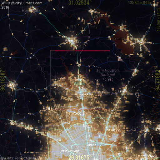
Analysis of Willis night lights 2016
Square area 10x10 km:
 1.83%
1.83%90-99
2.38%80-89
15.57%70-79
10.62%60-69
8.61%50-59
15.2%40-49
21.25%30-39
12.09%20-29
7.33%10-19
5.13%0-9
0%Square area 50x50 km:
1.45%90-99
1.93%80-89
3.93%70-79
3.58%60-69
5.41%50-59
6.61%40-49
7.19%30-39
6.46%20-29
6.08%10-19
8.97%0-9
48.38%Clear (daylight) street map image can be seen on geolist.org.
Map coordinates:
31° 1' 45.6" North, 96° 10' 59.1" West
30° 25' 29.7" North, 95° 28' 47.8" West
29° 49' 0.3" North, 94° 46' 36.6" West
Some cities around Willis sort by population:
• The Woodlands
29.7 km =18.5 mi,  181°
181°
• Conroe
12.8 km =8 mi,  169°
169°
• Spring
38.8 km =24.1 mi, 171°
• Cypress
54.8 km =34.1 mi,  202°
202°
• Huntsville
33.9 km =21.1 mi,  348°
348°
• Humble
51.8 km =32.2 mi,  156°
156°
• Tomball
38.7 km =24 mi, 199°
• Cleveland
39 km =24.2 mi,  103°
103°
4742170 (p: 6,313)
Sources (retrieved 2019-11-25):
» Earth at Night: Flat Maps 2012, 2016