Humble night lights from space
Night Light of Humble (Texas) from space (United States) Src. Average luminocity for 10x10km area is 82.6439% and for 50x50km: 71.1015%.
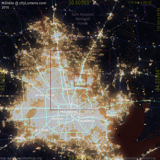
Analysis of Humble night lights 2016
Square area 10x10 km:
 20.83%
90-99
19.32%80-89
13.45%70-79
20.27%60-69
23.86%50-59
2.27%40-49
0%30-39
0%20-29
0%10-19
0%0-9
0%Square area 50x50 km:
22.69%90-99
16.71%80-89
9.25%70-79
10.05%60-69
10.98%50-59
7.42%40-49
6.59%30-39
4.42%20-29
2.83%10-19
3.07%0-9
6%Clear (daylight) street map image can be seen on geolist.org.
Map coordinates:
30° 36' 21.2" North, 95° 57' 55" West
29° 59' 55.8" North, 95° 15' 43.8" West
29° 23' 16.9" North, 94° 33' 32.5" West
Some cities around Humble sort by population:
• Houston
27.9 km =17.3 mi,  200°
200°
• The Woodlands
28.1 km =17.5 mi,  308°
308°
• Atascocita
8.2 km =5.1 mi,  90°
90°
• Spring
17.4 km =10.8 mi,  301°
301°
• Cloverleaf
26 km =16.2 mi,  160°
160°
• Aldine
13.6 km =8.5 mi,  237°
237°
• Jacinto City
25.9 km =16.1 mi,  173°
173°
• Highlands
28.2 km =17.5 mi,  135°
135°
4699442 (p: 15,665)
Sources (retrieved 2019-11-25):
» Earth at Night: Flat Maps 2012, 2016