Cleveland night lights from space
Night Light of Cleveland (Texas) from space (United States) Src. Average luminocity for 10x10km area is 34.2198% and for 50x50km: 13.0885%.
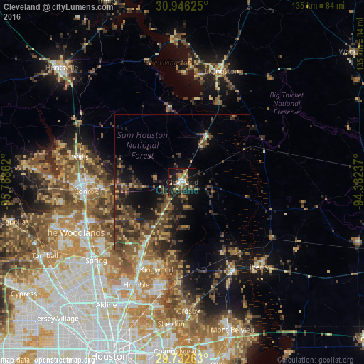
Analysis of Cleveland night lights 2016
Square area 10x10 km:
 2.56%
2.56%90-99
2.93%80-89
5.13%70-79
4.4%60-69
4.21%50-59
9.52%40-49
5.31%30-39
6.78%20-29
8.42%10-19
42.31%0-9
8.42%Square area 50x50 km:
0.27%90-99
0.37%80-89
1.17%70-79
1.48%60-69
2.06%50-59
3.35%40-49
4.12%30-39
5.73%20-29
5.14%10-19
8.43%0-9
67.88%Clear (daylight) street map image can be seen on geolist.org.
Map coordinates:
30° 56' 46.5" North, 95° 47' 19" West
30° 20' 28.8" North, 95° 5' 7.8" West
29° 43' 57.5" North, 94° 22' 56.5" West
Some cities around Cleveland sort by population:
• Conroe
35.7 km =22.2 mi,  264°
264°
• Atascocita
39.1 km =24.3 mi,  192°
192°
• Spring
43.1 km =26.8 mi,  227°
227°
• Humble
41.7 km =25.9 mi,  204°
204°
• Liberty
42.1 km =26.2 mi,  138°
138°
• West Livingston
40.5 km =25.2 mi,  11°
11°
• Dayton
38 km =23.6 mi,  149°
149°
• Willis
39 km =24.2 mi,  283°
283°
4682032 (p: 7,858)
Sources (retrieved 2019-11-25):
» Earth at Night: Flat Maps 2012, 2016