Tomball night lights from space
Night Light of Tomball (Texas) from space (United States) Src. Average luminocity for 10x10km area is 71.4432% and for 50x50km: 62.4216%.
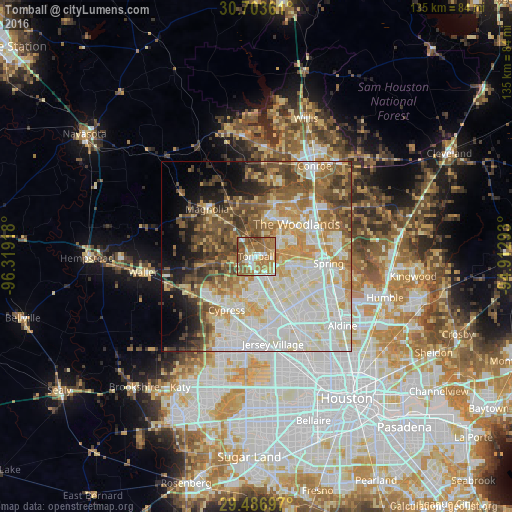
Analysis of Tomball night lights 2016
Square area 10x10 km:
 10.23%
90-99
8.71%80-89
12.12%70-79
12.5%60-69
29.17%50-59
21.21%40-49
4.92%30-39
1.14%20-29
0%10-19
0%0-9
0%Square area 50x50 km:
15.69%90-99
16.12%80-89
8.76%70-79
8.56%60-69
8.02%50-59
7.63%40-49
8.57%30-39
5.72%20-29
3.63%10-19
6.38%0-9
10.91%Clear (daylight) street map image can be seen on geolist.org.
Map coordinates:
30° 42' 13" North, 96° 19' 9" West
30° 5' 49.8" North, 95° 36' 57.8" West
29° 29' 13.1" North, 94° 54' 46.5" West
Some cities around Tomball sort by population:
• The Woodlands
13.9 km =8.6 mi,  60°
60°
• Conroe
28.4 km =17.6 mi,  32°
32°
• Spring
19.2 km =11.9 mi,  95°
95°
• Cypress
16.2 km =10.1 mi,  208°
208°
• Aldine
29.2 km =18.1 mi,  128°
128°
• Humble
35.8 km =22.2 mi,  107°
107°
• Jersey Village
23.8 km =14.8 mi,  167°
167°
• Prairie View
35.8 km =22.2 mi,  269°
269°
4737094 (p: 11,540)
Sources (retrieved 2019-11-25):
» Earth at Night: Flat Maps 2012, 2016