West Haverstraw night lights from space
Night Light of West Haverstraw (New York) from space (United States) Src. Average luminocity for 10x10km area is 50.2532% and for 50x50km: 37.1278%.
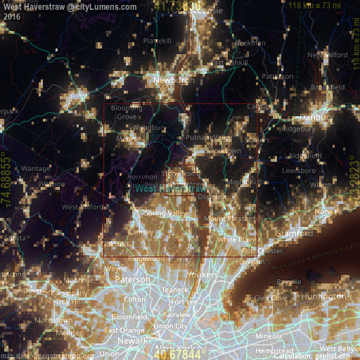
Analysis of West Haverstraw night lights 2016
Square area 10x10 km:
 3.41%
3.41%90-99
4.87%80-89
7.47%70-79
6.98%60-69
10.71%50-59
13.31%40-49
15.42%30-39
10.39%20-29
22.56%10-19
4.71%0-9
0.16%Square area 50x50 km:
3.47%90-99
4.55%80-89
4.51%70-79
6.56%60-69
11%50-59
7.34%40-49
5.07%30-39
5.66%20-29
8.29%10-19
16.63%0-9
26.92%Clear (daylight) street map image can be seen on geolist.org.
Map coordinates:
41° 44' 10.9" North, 74° 41' 18.8" West
41° 12' 34.3" North, 73° 59' 7.5" West
40° 40' 42.4" North, 73° 16' 56.3" West
Some cities around West Haverstraw sort by population:
• New City
6.9 km =4.3 mi,  182°
182°
• Haverstraw
2.2 km =1.4 mi,  127°
127°
• Stony Point
2.2 km =1.4 mi,  356°
356°
• Congers
7.4 km =4.6 mi,  152°
152°
• Croton-on-Hudson
7.9 km =4.9 mi,  90°
90°
• Mount Ivy
4.9 km =3 mi,  238°
238°
• New Hempstead
7.8 km =4.8 mi,  211°
211°
• Thiells
2.7 km =1.7 mi,  272°
272°
5143830 (p: 10,421)
Sources (retrieved 2019-11-25):
» Earth at Night: Flat Maps 2012, 2016