New Hempstead night lights from space
Night Light of New Hempstead (New York) from space (United States) Src. Average luminocity for 10x10km area is 65.3019% and for 50x50km: 44.3803%.
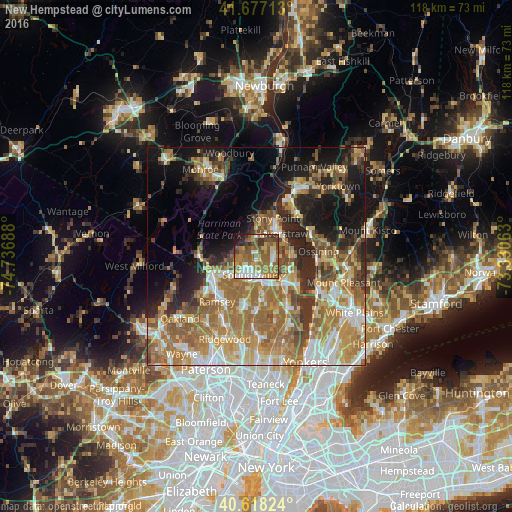
Analysis of New Hempstead night lights 2016
Square area 10x10 km:
 9.74%
9.74%90-99
11.85%80-89
5.19%70-79
10.23%60-69
23.05%50-59
19.81%40-49
6.66%30-39
6.66%20-29
3.57%10-19
3.25%0-9
0%Square area 50x50 km:
5.77%90-99
6.91%80-89
5.88%70-79
8.61%60-69
12.5%50-59
7.71%40-49
5%30-39
4.96%20-29
7.65%10-19
12.76%0-9
22.25%Clear (daylight) street map image can be seen on geolist.org.
Map coordinates:
41° 40' 37.7" North, 74° 44' 12.8" West
41° 8' 59.4" North, 74° 2' 1.5" West
40° 37' 5.7" North, 73° 19' 50.3" West
Some cities around New Hempstead sort by population:
• New City
3.7 km =2.3 mi,  93°
93°
• Spring Valley
4.2 km =2.6 mi,  191°
191°
• New Square
1.2 km =0.7 mi,  162°
162°
• Hillcrest
2.5 km =1.6 mi, 193°
• Mount Ivy
4.1 km =2.5 mi,  358°
358°
• Viola
4.3 km =2.7 mi,  249°
249°
• Wesley Hills
3.2 km =2 mi,  289°
289°
• Kaser
4.2 km =2.6 mi,  221°
221°
5120479 (p: 5,312)
Sources (retrieved 2019-11-25):
» Earth at Night: Flat Maps 2012, 2016