Stony Point night lights from space
Night Light of Stony Point (New York) from space (United States) Src. Average luminocity for 10x10km area is 46.112% and for 50x50km: 34.9909%.
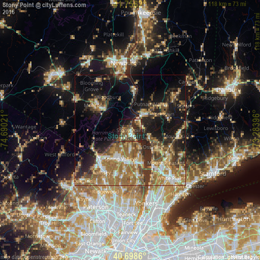
Analysis of Stony Point night lights 2016
Square area 10x10 km:
 3.9%
3.9%90-99
5.68%80-89
6.82%70-79
6.01%60-69
8.12%50-59
8.6%40-49
14.12%30-39
10.06%20-29
21.1%10-19
11.36%0-9
4.22%Square area 50x50 km:
3.33%90-99
4.24%80-89
4.38%70-79
5.78%60-69
9.75%50-59
6.75%40-49
5.07%30-39
5.62%20-29
8.29%10-19
17%0-9
29.8%Clear (daylight) street map image can be seen on geolist.org.
Map coordinates:
41° 45' 22.3" North, 74° 41' 24.8" West
41° 13' 46.3" North, 73° 59' 13.5" West
40° 41' 55" North, 73° 17' 2.3" West
Some cities around Stony Point sort by population:
• New City
9.1 km =5.7 mi,  181°
181°
• Peekskill
8.7 km =5.4 mi,  39°
39°
• Haverstraw
4 km =2.5 mi,  152°
152°
• West Haverstraw
2.2 km =1.4 mi, 176°
• Congers
9.4 km =5.8 mi,  158°
158°
• Croton-on-Hudson
8.4 km =5.2 mi,  106°
106°
• Mount Ivy
6.2 km =3.9 mi,  220°
220°
• Thiells
3.3 km =2.1 mi,  230°
230°
5139927 (p: 12,147)
Sources (retrieved 2019-11-25):
» Earth at Night: Flat Maps 2012, 2016