Croton-on-Hudson night lights from space
Night Light of Croton-on-Hudson (New York) from space (United States) Src. Average luminocity for 10x10km area is 32.6981% and for 50x50km: 38.437%.
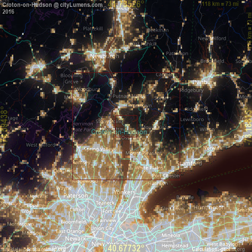
Analysis of Croton-on-Hudson night lights 2016
Square area 10x10 km:
 0.65%
0.65%90-99
1.46%80-89
5.84%70-79
2.44%60-69
4.71%50-59
7.47%40-49
8.77%30-39
2.27%20-29
30.52%10-19
33.6%0-9
2.27%Square area 50x50 km:
3.76%90-99
4.82%80-89
4.93%70-79
6.66%60-69
11.17%50-59
7.16%40-49
5.42%30-39
5.89%20-29
8.47%10-19
17.19%0-9
24.54%Clear (daylight) street map image can be seen on geolist.org.
Map coordinates:
41° 44' 6.9" North, 74° 35' 39.8" West
41° 12' 30.3" North, 73° 53' 28.5" West
40° 40' 38.4" North, 73° 11' 17.3" West
Some cities around Croton-on-Hudson sort by population:
• New City
10.6 km =6.6 mi,  230°
230°
• Ossining
5.6 km =3.5 mi,  153°
153°
• Peekskill
9.4 km =5.8 mi,  344°
344°
• Haverstraw
6.3 km =3.9 mi,  258°
258°
• Stony Point
8.4 km =5.2 mi,  286°
286°
• West Haverstraw
7.9 km =4.9 mi,  270°
270°
• Congers
7.9 km =4.9 mi,  215°
215°
• Briarcliff Manor
9 km =5.6 mi,  141°
141°
5114221 (p: 8,269)
Sources (retrieved 2019-11-25):
» Earth at Night: Flat Maps 2012, 2016