Thiells night lights from space
Night Light of Thiells (New York) from space (United States) Src. Average luminocity for 10x10km area is 46.0779% and for 50x50km: 36.0891%.
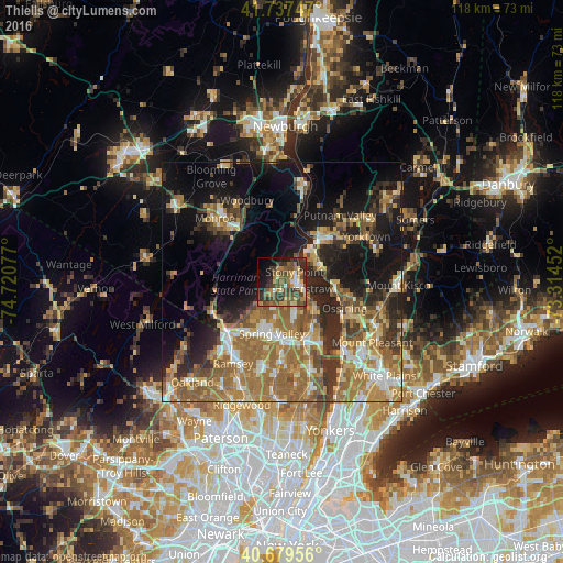
Analysis of Thiells night lights 2016
Square area 10x10 km:
 3.08%
3.08%90-99
4.55%80-89
5.84%70-79
7.47%60-69
8.6%50-59
13.31%40-49
15.58%30-39
11.36%20-29
9.25%10-19
13.15%0-9
7.79%Square area 50x50 km:
3.44%90-99
4.48%80-89
4.44%70-79
6.39%60-69
10.51%50-59
7.07%40-49
4.86%30-39
5.51%20-29
8.02%10-19
15.47%0-9
29.82%Clear (daylight) street map image can be seen on geolist.org.
Map coordinates:
41° 44' 14.9" North, 74° 43' 14.8" West
41° 12' 38.3" North, 74° 1' 3.5" West
40° 40' 46.4" North, 73° 18' 52.3" West
Some cities around Thiells sort by population:
• New City
7.4 km =4.6 mi,  161°
161°
• Haverstraw
4.7 km =2.9 mi,  108°
108°
• Stony Point
3.3 km =2.1 mi,  50°
50°
• West Haverstraw
2.7 km =1.7 mi,  92°
92°
• New Square
8 km =5 mi,  187°
187°
• Mount Ivy
3 km =1.9 mi,  208°
208°
• Wesley Hills
7.2 km =4.5 mi,  217°
217°
• New Hempstead
6.9 km =4.3 mi, 191°
5140789 (p: 5,032)
Sources (retrieved 2019-11-25):
» Earth at Night: Flat Maps 2012, 2016