Haverstraw night lights from space
Night Light of Haverstraw (New York) from space (United States) Src. Average luminocity for 10x10km area is 50.0422% and for 50x50km: 39.2299%.
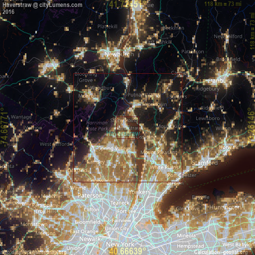
Analysis of Haverstraw night lights 2016
Square area 10x10 km:
 3.73%
3.73%90-99
5.03%80-89
8.44%70-79
8.77%60-69
7.31%50-59
13.47%40-49
13.15%30-39
6.49%20-29
28.08%10-19
5.52%0-9
0%Square area 50x50 km:
3.84%90-99
4.99%80-89
4.83%70-79
7.02%60-69
11.62%50-59
7.62%40-49
5.34%30-39
5.74%20-29
8.47%10-19
16.85%0-9
23.68%Clear (daylight) street map image can be seen on geolist.org.
Map coordinates:
41° 43' 28.2" North, 74° 40' 3.8" West
41° 11' 51.3" North, 73° 57' 52.5" West
40° 39' 59" North, 73° 15' 41.3" West
Some cities around Haverstraw sort by population:
• New City
5.9 km =3.7 mi,  200°
200°
• Stony Point
4 km =2.5 mi,  332°
332°
• West Haverstraw
2.2 km =1.4 mi,  307°
307°
• Congers
5.5 km =3.4 mi,  162°
162°
• Croton-on-Hudson
6.3 km =3.9 mi,  78°
78°
• Mount Ivy
6 km =3.7 mi,  258°
258°
• New Hempstead
7.9 km =4.9 mi,  227°
227°
• Thiells
4.7 km =2.9 mi,  288°
288°
5120238 (p: 12,187)
Sources (retrieved 2019-11-25):
» Earth at Night: Flat Maps 2012, 2016