Congers night lights from space
Night Light of Congers (New York) from space (United States) Src. Average luminocity for 10x10km area is 50.0666% and for 50x50km: 46.2307%.
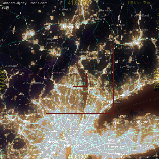
Analysis of Congers night lights 2016
Square area 10x10 km:
 2.27%
2.27%90-99
3.9%80-89
7.47%70-79
8.6%60-69
12.01%50-59
17.86%40-49
10.55%30-39
5.36%20-29
27.76%10-19
4.22%0-9
0%Square area 50x50 km:
6.06%90-99
7.16%80-89
6.1%70-79
8.64%60-69
12.71%50-59
7.92%40-49
5.37%30-39
5.68%20-29
8.46%10-19
15.41%0-9
16.51%Clear (daylight) street map image can be seen on geolist.org.
Map coordinates:
41° 40' 40.6" North, 74° 38' 54.8" West
41° 9' 2.3" North, 73° 56' 43.5" West
40° 37' 8.7" North, 73° 14' 32.3" West
Some cities around Congers sort by population:
• New City
3.7 km =2.3 mi,  264°
264°
• Ossining
7.2 km =4.5 mi,  79°
79°
• Haverstraw
5.5 km =3.4 mi,  342°
342°
• West Haverstraw
7.4 km =4.6 mi,  332°
332°
• Valley Cottage
3.7 km =2.3 mi,  193°
193°
• New Square
7.1 km =4.4 mi, 260°
• Nyack
7.1 km =4.4 mi,  160°
160°
• New Hempstead
7.4 km =4.6 mi,  269°
269°
5113500 (p: 8,363)
Sources (retrieved 2019-11-25):
» Earth at Night: Flat Maps 2012, 2016