Mount Ivy night lights from space
Night Light of Mount Ivy (New York) from space (United States) Src. Average luminocity for 10x10km area is 52.086% and for 50x50km: 38.986%.
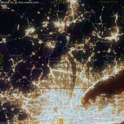
Analysis of Mount Ivy night lights 2016
Square area 10x10 km:
 4.06%
4.06%90-99
7.14%80-89
4.55%70-79
9.25%60-69
12.18%50-59
21.59%40-49
11.2%30-39
7.95%20-29
5.03%10-19
11.53%0-9
5.52%Square area 50x50 km:
3.97%90-99
5.07%80-89
4.88%70-79
7.52%60-69
11.56%50-59
7.55%40-49
5.02%30-39
5.2%20-29
7.87%10-19
13.93%0-9
27.43%Clear (daylight) street map image can be seen on geolist.org.
Map coordinates:
41° 42' 49.6" North, 74° 44' 16.8" West
41° 11' 12.3" North, 74° 2' 5.5" West
40° 39' 19.7" North, 73° 19' 54.3" West
Some cities around Mount Ivy sort by population:
• New City
5.8 km =3.6 mi,  138°
138°
• Haverstraw
6 km =3.7 mi,  78°
78°
• Stony Point
6.2 km =3.9 mi,  40°
40°
• West Haverstraw
4.9 km =3 mi,  58°
58°
• New Square
5.3 km =3.3 mi,  175°
175°
• Wesley Hills
4.2 km =2.6 mi,  223°
223°
• New Hempstead
4.1 km =2.5 mi, 178°
• Thiells
3 km =1.9 mi,  28°
28°
5127741 (p: 6,878)
Sources (retrieved 2019-11-25):
» Earth at Night: Flat Maps 2012, 2016