Waverly night lights from space
Night Light of Waverly (Iowa) from space (United States) Src. Average luminocity for 10x10km area is 19.2303% and for 50x50km: 5.0551%.
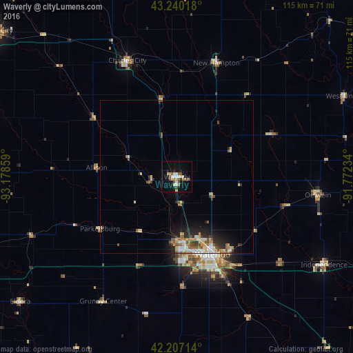
Analysis of Waverly night lights 2016
Square area 10x10 km:
 2.42%
2.42%90-99
2.42%80-89
2.58%70-79
2.42%60-69
1.97%50-59
3.03%40-49
3.94%30-39
0.3%20-29
2.73%10-19
15.3%0-9
62.88%Square area 50x50 km:
0.69%90-99
0.74%80-89
0.84%70-79
0.56%60-69
0.68%50-59
0.83%40-49
0.64%30-39
0.45%20-29
1.4%10-19
2.73%0-9
90.44%Clear (daylight) street map image can be seen on geolist.org.
Map coordinates:
43° 14' 24.6" North, 93° 10' 42.9" West
42° 43' 32.9" North, 92° 28' 31.7" West
42° 12' 25.7" North, 91° 46' 20.4" West
Some cities around Waverly sort by population:
• Waterloo
28.1 km =17.5 mi,  157°
157°
• Cedar Falls
22.2 km =13.8 mi,  173°
173°
• Mason City
75.8 km =47.1 mi,  308°
308°
• Charles City
41.1 km =25.5 mi,  337°
337°
• Oelwein
46.3 km =28.8 mi,  97°
97°
• Independence
55.9 km =34.7 mi,  120°
120°
• Iowa Falls
67.4 km =41.9 mi,  250°
250°
• Vinton
72.2 km =44.9 mi,  149°
149°
4881024 (p: 10,066)
Sources (retrieved 2019-11-25):
» Earth at Night: Flat Maps 2012, 2016