Stansbury park night lights from space
Night Light of Stansbury park (Utah) from space (United States) Src. Average luminocity for 10x10km area is 8.6364% and for 50x50km: 10.7915%.
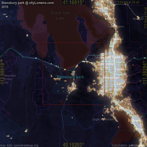
Analysis of Stansbury park night lights 2016
Square area 10x10 km:
 0%
0%90-99
0%80-89
0.65%70-79
0.81%60-69
1.46%50-59
3.73%40-49
1.79%30-39
2.27%20-29
0.49%10-19
0.65%0-9
88.15%Square area 50x50 km:
1.2%90-99
1.66%80-89
1.9%70-79
1.74%60-69
1.68%50-59
1.45%40-49
1.38%30-39
1.32%20-29
2.5%10-19
5.54%0-9
79.64%Clear (daylight) street map image can be seen on geolist.org.
Map coordinates:
41° 10' 8.9" North, 112° 59' 57.1" West
40° 38' 15.8" North, 112° 17' 45.8" West
40° 6' 7.3" North, 111° 35' 34.6" West
Some cities around Stansbury park sort by population:
• West Valley City
25.6 km =15.9 mi,  76°
76°
• Taylorsville
30.3 km =18.8 mi, 83°
• Kearns
25.4 km =15.8 mi, 84°
• Tooele
11.9 km =7.4 mi,  180°
180°
• Herriman
26.1 km =16.2 mi,  121°
121°
• Magna
18.2 km =11.3 mi,  64°
64°
• Oquirrh
22.1 km =13.7 mi,  92°
92°
• Grantsville
14.8 km =9.2 mi,  253°
253°
5782055 (p: 5,145)
Sources (retrieved 2019-11-25):
» Earth at Night: Flat Maps 2012, 2016