Oquirrh night lights from space
Night Light of Oquirrh (Utah) from space (United States) Src. Average luminocity for 10x10km area is 68.1266% and for 50x50km: 37.3355%.
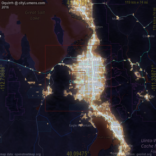
Analysis of Oquirrh night lights 2016
Square area 10x10 km:
 8.6%
8.6%90-99
14.77%80-89
21.27%70-79
15.1%60-69
8.77%50-59
7.95%40-49
2.44%30-39
6.01%20-29
10.23%10-19
4.87%0-9
0%Square area 50x50 km:
9.67%90-99
9.35%80-89
5.77%70-79
4.26%60-69
4.38%50-59
3.9%40-49
2.69%30-39
2.93%20-29
5.54%10-19
8.91%0-9
42.59%Clear (daylight) street map image can be seen on geolist.org.
Map coordinates:
41° 9' 43.1" North, 112° 44' 13.1" West
40° 37' 49.8" North, 112° 2' 1.8" West
40° 5' 41.1" North, 111° 19' 50.6" West
Some cities around Oquirrh sort by population:
• West Valley City
7.3 km =4.5 mi,  22°
22°
• West Jordan
8.3 km =5.2 mi,  106°
106°
• South Jordan
11.6 km =7.2 mi,  130°
130°
• Taylorsville
9 km =5.6 mi,  62°
62°
• South Jordan Heights
10.3 km =6.4 mi,  136°
136°
• Kearns
4.6 km =2.9 mi,  44°
44°
• Midvale
11.5 km =7.1 mi,  100°
100°
• Magna
10.4 km =6.5 mi,  326°
326°
5779333 (p: 11,668)
Sources (retrieved 2019-11-25):
» Earth at Night: Flat Maps 2012, 2016