Grantsville night lights from space
Night Light of Grantsville (Utah) from space (United States) Src. Average luminocity for 10x10km area is 7.6071% and for 50x50km: 2.6251%.
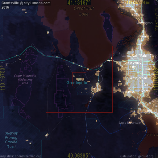
Analysis of Grantsville night lights 2016
Square area 10x10 km:
 0%
0%90-99
0%80-89
0.81%70-79
1.14%60-69
3.25%50-59
1.3%40-49
1.3%30-39
2.44%20-29
1.46%10-19
1.3%0-9
87.01%Square area 50x50 km:
0.1%90-99
0.15%80-89
0.34%70-79
0.42%60-69
0.52%50-59
0.52%40-49
0.55%30-39
0.41%20-29
0.35%10-19
1.59%0-9
95.06%Clear (daylight) street map image can be seen on geolist.org.
Map coordinates:
41° 7' 54" North, 113° 10' 3.1" West
40° 35' 59.8" North, 112° 27' 51.8" West
40° 3' 50.2" North, 111° 45' 40.6" West
Some cities around Grantsville sort by population:
• West Valley City
40.4 km =25.1 mi,  75°
75°
• South Jordan Heights
43.7 km =27.2 mi,  95°
95°
• Kearns
40.1 km =24.9 mi, 80°
• Tooele
16 km =9.9 mi,  118°
118°
• Herriman
37.7 km =23.4 mi, 104°
• Magna
32.9 km =20.4 mi,  68°
68°
• Oquirrh
36.5 km =22.7 mi, 84°
• Stansbury park
14.8 km =9.2 mi, 73°
5775346 (p: 10,027)
Sources (retrieved 2019-11-25):
» Earth at Night: Flat Maps 2012, 2016