South Haven night lights from space
Night Light of South Haven (Indiana) from space (United States) Src. Average luminocity for 10x10km area is 41.1429% and for 50x50km: 26.9545%.
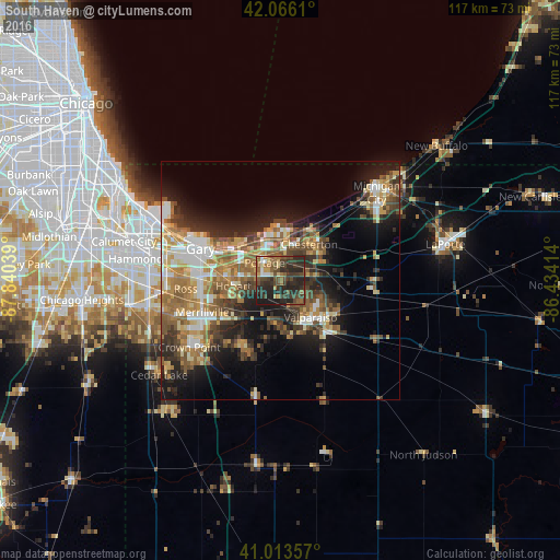
Analysis of South Haven night lights 2016
Square area 10x10 km:
 2.21%
2.21%90-99
2.21%80-89
4.59%70-79
2.72%60-69
9.35%50-59
7.65%40-49
12.59%30-39
16.84%20-29
32.99%10-19
8.84%0-9
0%Square area 50x50 km:
3.22%90-99
3.91%80-89
3.61%70-79
3.94%60-69
5.31%50-59
5.07%40-49
4.43%30-39
4.43%20-29
6.89%10-19
12.05%0-9
47.14%Clear (daylight) street map image can be seen on geolist.org.
Map coordinates:
42° 3' 58" North, 87° 50' 25.4" West
41° 32' 31.1" North, 87° 8' 14.1" West
41° 0' 48.9" North, 86° 26' 2.9" West
Some cities around South Haven sort by population:
• Gary
18.3 km =11.4 mi,  288°
288°
• Portage
5 km =3.1 mi,  319°
319°
• Merrillville
17.6 km =10.9 mi,  247°
247°
• Valparaiso
9.9 km =6.2 mi,  140°
140°
• Hobart
9.9 km =6.2 mi,  263°
263°
• Chesterton
9.8 km =6.1 mi,  38°
38°
• Lake Station
9.2 km =5.7 mi, 293°
• Lakes of the Four Seasons
15.9 km =9.9 mi,  203°
203°
4926613 (p: 5,282)
Sources (retrieved 2019-11-25):
» Earth at Night: Flat Maps 2012, 2016