Merrillville night lights from space
Night Light of Merrillville (Indiana) from space (United States) Src. Average luminocity for 10x10km area is 72.2687% and for 50x50km: 42.6427%.
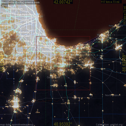

Analysis of Merrillville night lights 2016
Square area 10x10 km:
 11.9%
11.9%90-99
14.8%80-89
10.71%70-79
13.27%60-69
21.26%50-59
14.12%40-49
8.33%30-39
3.57%20-29
2.04%10-19
0%0-9
0%Square area 50x50 km:
10.05%90-99
8.42%80-89
5.43%70-79
6.09%60-69
6.8%50-59
5.86%40-49
4.76%30-39
4.89%20-29
7.21%10-19
10.13%0-9
30.35%Clear (daylight) street map image can be seen on geolist.org.
Map coordinates:
42° 0' 26.7" North, 88° 2' 9.4" West
41° 28' 58.1" North, 87° 19' 58.1" West
40° 57' 14.1" North, 86° 37' 46.9" West
Some cities around Merrillville sort by population:
• Gary
12.3 km =7.6 mi,  354°
354°
• Crown Point
7.8 km =4.8 mi,  200°
200°
• Schererville
10.2 km =6.3 mi,  267°
267°
• Hobart
8.5 km =5.3 mi,  49°
49°
• Highland
12.7 km =7.9 mi,  308°
308°
• Griffith
9.1 km =5.7 mi,  303°
303°
• Saint John
12 km =7.5 mi,  252°
252°
• Winfield
9.9 km =6.2 mi,  150°
150°
4923482 (p: 35,224)
Sources (retrieved 2019-11-25):
» Earth at Night: Flat Maps 2012, 2016