Lake Station night lights from space
Night Light of Lake Station (Indiana) from space (United States) Src. Average luminocity for 10x10km area is 68.1688% and for 50x50km: 34.431%.
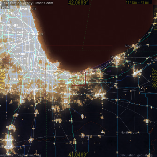
Analysis of Lake Station night lights 2016
Square area 10x10 km:
 4.87%
4.87%90-99
8.77%80-89
12.01%70-79
14.61%60-69
26.79%50-59
20.94%40-49
9.9%30-39
2.11%20-29
0%10-19
0%0-9
0%Square area 50x50 km:
6.84%90-99
6.14%80-89
4.09%70-79
4.54%60-69
5.9%50-59
5.7%40-49
4.76%30-39
4.97%20-29
7.29%10-19
11.1%0-9
38.68%Clear (daylight) street map image can be seen on geolist.org.
Map coordinates:
42° 5' 56" North, 87° 56' 31.4" West
41° 34' 30.1" North, 87° 14' 20.1" West
41° 2' 48.8" North, 86° 32' 8.9" West
Some cities around Lake Station sort by population:
• Gary
9.2 km =5.7 mi,  282°
282°
• Portage
5.2 km =3.2 mi,  88°
88°
• Merrillville
12.9 km =8 mi,  217°
217°
• Hobart
4.9 km =3 mi,  195°
195°
• Highland
17.9 km =11.1 mi,  262°
262°
• Griffith
16.2 km =10.1 mi,  251°
251°
• Chesterton
15.1 km =9.4 mi,  74°
74°
• South Haven
9.2 km =5.7 mi,  113°
113°
4922541 (p: 12,054)
Sources (retrieved 2019-11-25):
» Earth at Night: Flat Maps 2012, 2016