Lakes of the Four Seasons night lights from space
Night Light of Lakes of the Four Seasons (Indiana) from space (United States) Src. Average luminocity for 10x10km area is 19.9898% and for 50x50km: 29.6901%.
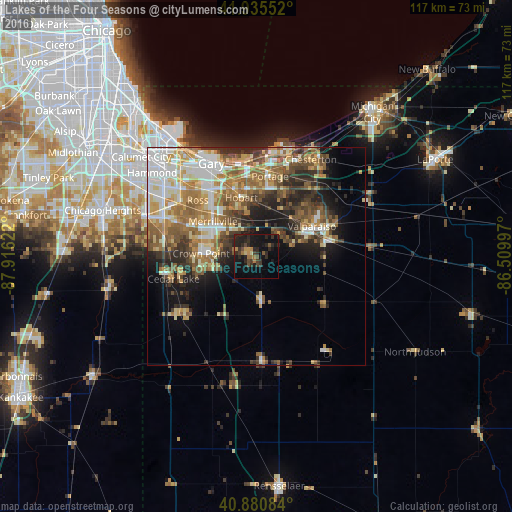
Analysis of Lakes of the Four Seasons night lights 2016
Square area 10x10 km:
 0%
0%90-99
0%80-89
1.36%70-79
3.06%60-69
3.74%50-59
1.7%40-49
4.08%30-39
6.97%20-29
14.46%10-19
25.68%0-9
38.95%Square area 50x50 km:
4.71%90-99
5.13%80-89
4.02%70-79
4.38%60-69
5.54%50-59
5.51%40-49
4.14%30-39
4.2%20-29
6.23%10-19
8.22%0-9
47.92%Clear (daylight) street map image can be seen on geolist.org.
Map coordinates:
41° 56' 7.9" North, 87° 54' 58.4" West
41° 24' 37.2" North, 87° 12' 47.1" West
40° 52' 51" North, 86° 30' 35.9" West
Some cities around Lakes of the Four Seasons sort by population:
• Portage
18.7 km =11.6 mi,  9°
9°
• Merrillville
12.8 km =8 mi,  308°
308°
• Valparaiso
14.5 km =9 mi,  61°
61°
• Crown Point
12.7 km =7.9 mi,  273°
273°
• Hobart
14 km =8.7 mi,  345°
345°
• Lake Station
18.4 km =11.4 mi, 353°
• Winfield
5.2 km =3.2 mi,  263°
263°
• South Haven
15.9 km =9.9 mi,  23°
23°
4922562 (p: 7,033)
Sources (retrieved 2019-11-25):
» Earth at Night: Flat Maps 2012, 2016