Chesterton night lights from space
Night Light of Chesterton (Indiana) from space (United States) Src. Average luminocity for 10x10km area is 39.8344% and for 50x50km: 21.2728%.
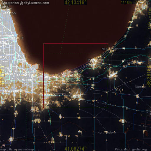
Analysis of Chesterton night lights 2016
Square area 10x10 km:
 1.46%
1.46%90-99
1.79%80-89
4.55%70-79
8.28%60-69
5.19%50-59
8.44%40-49
15.91%30-39
13.47%20-29
15.26%10-19
19.97%0-9
5.68%Square area 50x50 km:
2.35%90-99
2.84%80-89
2.75%70-79
2.93%60-69
3.77%50-59
3.92%40-49
3.95%30-39
3.94%20-29
6.16%10-19
11.13%0-9
56.27%Clear (daylight) street map image can be seen on geolist.org.
Map coordinates:
42° 8' 3" North, 87° 46' 2.4" West
41° 36' 38.1" North, 87° 3' 51.1" West
41° 4' 57.9" North, 86° 21' 39.9" West
Some cities around Chesterton sort by population:
• Gary
23.5 km =14.6 mi,  265°
265°
• Portage
10.1 km =6.3 mi,  247°
247°
• Valparaiso
15.3 km =9.5 mi,  179°
179°
• Michigan City
17.7 km =11 mi,  52°
52°
• Hobart
18.1 km =11.2 mi,  241°
241°
• Lake Station
15.1 km =9.4 mi, 254°
• Westville
15.6 km =9.7 mi,  119°
119°
• South Haven
9.8 km =6.1 mi,  218°
218°
4918962 (p: 13,433)
Sources (retrieved 2019-11-25):
» Earth at Night: Flat Maps 2012, 2016