Scarsdale night lights from space
Night Light of Scarsdale (New York) from space (United States) Src. Average luminocity for 10x10km area is 82.3401% and for 50x50km: 59.6184%.
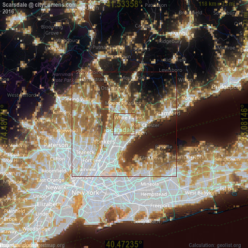
Analysis of Scarsdale night lights 2016
Square area 10x10 km:
 17.86%
90-99
20.75%80-89
9.52%70-79
28.57%60-69
22.96%50-59
0.34%40-49
0%30-39
0%20-29
0%10-19
0%0-9
0%Square area 50x50 km:
15.3%90-99
12.52%80-89
6.49%70-79
8.79%60-69
11.92%50-59
8.35%40-49
5.76%30-39
5.38%20-29
7.91%10-19
8.84%0-9
8.75%Clear (daylight) street map image can be seen on geolist.org.
Map coordinates:
41° 32' 0.9" North, 74° 29' 15.8" West
41° 0' 18.4" North, 73° 47' 4.5" West
40° 28' 20.5" North, 73° 4' 53.3" West
Some cities around Scarsdale sort by population:
• Greenburgh
5.8 km =3.6 mi,  302°
302°
• White Plains
3.7 km =2.3 mi,  29°
29°
• Harrison
7.3 km =4.5 mi,  123°
123°
• Eastchester
5.6 km =3.5 mi,  201°
201°
• Wykagyl
7.2 km =4.5 mi,  189°
189°
• Greenville
3.2 km =2 mi,  245°
245°
• Tuckahoe
7.1 km =4.4 mi,  210°
210°
• Hartsdale
1.9 km =1.2 mi,  323°
323°
5136433 (p: 17,885)
Sources (retrieved 2019-11-25):
» Earth at Night: Flat Maps 2012, 2016