Eastchester night lights from space
Night Light of Eastchester (New York) from space (United States) Src. Average luminocity for 10x10km area is 86.9915% and for 50x50km: 68.3627%.
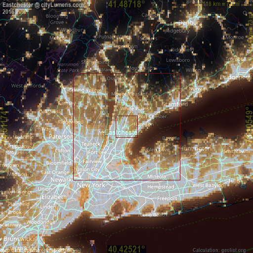
Analysis of Eastchester night lights 2016
Square area 10x10 km:
 29.42%
90-99
24.49%80-89
10.2%70-79
21.6%60-69
13.61%50-59
0.68%40-49
0%30-39
0%20-29
0%10-19
0%0-9
0%Square area 50x50 km:
22.79%90-99
14.79%80-89
6.85%70-79
9.13%60-69
12.53%50-59
7.59%40-49
4.87%30-39
4.96%20-29
6.28%10-19
5.6%0-9
4.62%Clear (daylight) street map image can be seen on geolist.org.
Map coordinates:
41° 29' 13.8" North, 74° 30' 42.3" West
40° 57' 30" North, 73° 48' 31" West
40° 25' 30.8" North, 73° 6' 19.8" West
Some cities around Eastchester sort by population:
• New Rochelle
5.7 km =3.5 mi,  157°
157°
• Mount Vernon
5.6 km =3.5 mi,  205°
205°
• Scarsdale
5.6 km =3.5 mi,  21°
21°
• Wykagyl
2 km =1.2 mi, 156°
• Greenville
4 km =2.5 mi,  346°
346°
• Pelham
5.4 km =3.4 mi,  179°
179°
• Tuckahoe
1.8 km =1.1 mi,  240°
240°
• Bronxville
3 km =1.9 mi,  221°
221°
5116118 (p: 19,554)
Sources (retrieved 2019-11-25):
» Earth at Night: Flat Maps 2012, 2016