Robinson night lights from space
Night Light of Robinson (Illinois) from space (United States) Src. Average luminocity for 10x10km area is 23.0925% and for 50x50km: 1.6881%.
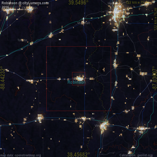
Analysis of Robinson night lights 2016
Square area 10x10 km:
 3.41%
3.41%90-99
5.52%80-89
2.6%70-79
2.6%60-69
1.46%50-59
1.95%40-49
2.6%30-39
3.25%20-29
1.79%10-19
25%0-9
49.84%Square area 50x50 km:
0.16%90-99
0.24%80-89
0.26%70-79
0.13%60-69
0.23%50-59
0.17%40-49
0.26%30-39
0.35%20-29
0.24%10-19
1.12%0-9
96.85%Clear (daylight) street map image can be seen on geolist.org.
Map coordinates:
39° 32' 58.6" North, 88° 26' 32.4" West
39° 0' 19.2" North, 87° 44' 21.1" West
38° 27' 24.6" North, 87° 2' 9.9" West
Some cities around Robinson sort by population:
• Terre Haute
58.5 km =36.4 mi,  28°
28°
• Charleston
66.3 km =41.2 mi,  325°
325°
• Vincennes
40.8 km =25.4 mi,  153°
153°
• Washington
62.4 km =38.8 mi,  128°
128°
• Olney
42.8 km =26.6 mi,  224°
224°
• Paris
67.5 km =41.9 mi,  3°
3°
• Mount Carmel
66.1 km =41.1 mi,  181°
181°
• Linton
49.6 km =30.8 mi,  86°
86°
4248256 (p: 7,631)
Sources (retrieved 2019-11-25):
» Earth at Night: Flat Maps 2012, 2016