Olney night lights from space
Night Light of Olney (Illinois) from space (United States) Src. Average luminocity for 10x10km area is 22.4082% and for 50x50km: 1.8159%.
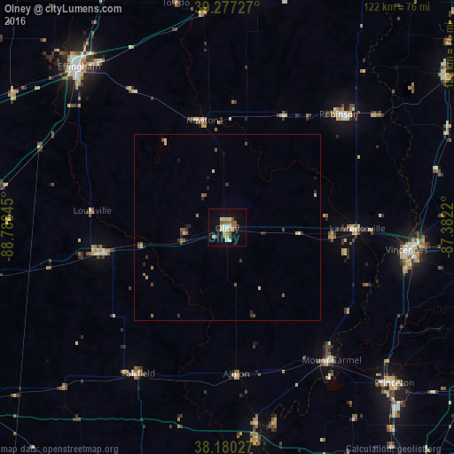
Analysis of Olney night lights 2016
Square area 10x10 km:
 2.55%
2.55%90-99
4.08%80-89
4.76%70-79
0.17%60-69
3.91%50-59
4.42%40-49
1.19%30-39
2.21%20-29
0.85%10-19
18.88%0-9
56.97%Square area 50x50 km:
0.1%90-99
0.23%80-89
0.35%70-79
0.05%60-69
0.35%50-59
0.39%40-49
0.24%30-39
0.31%20-29
0.32%10-19
0.94%0-9
96.72%Clear (daylight) street map image can be seen on geolist.org.
Map coordinates:
39° 16' 38.2" North, 88° 47' 18.4" West
38° 43' 51.2" North, 88° 5' 7.2" West
38° 10' 49" North, 87° 22' 55.9" West
Some cities around Olney sort by population:
• Vincennes
48.7 km =30.3 mi,  97°
97°
• Effingham
58.7 km =36.5 mi,  317°
317°
• Princeton
61.4 km =38.2 mi,  132°
132°
• Robinson
42.8 km =26.6 mi,  44°
44°
• Salem
75.6 km =47 mi,  261°
261°
• Mount Carmel
45.4 km =28.2 mi,  141°
141°
• Carmi
71.4 km =44.4 mi,  185°
185°
• Fairfield
45.8 km =28.5 mi,  211°
211°
4246382 (p: 9,005)
Sources (retrieved 2019-11-25):
» Earth at Night: Flat Maps 2012, 2016