Linton night lights from space
Night Light of Linton (Indiana) from space (United States) Src. Average luminocity for 10x10km area is 11.2289% and for 50x50km: 3.1673%.
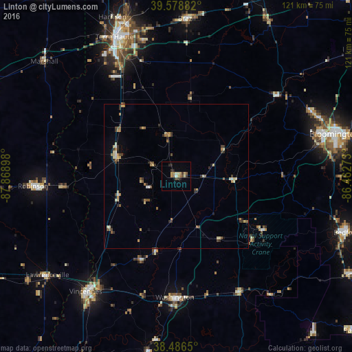
Analysis of Linton night lights 2016
Square area 10x10 km:
 0.49%
0.49%90-99
1.62%80-89
2.27%70-79
1.46%60-69
0.81%50-59
1.79%40-49
1.3%30-39
2.11%20-29
3.08%10-19
0%0-9
85.06%Square area 50x50 km:
0.12%90-99
0.22%80-89
0.75%70-79
0.44%60-69
0.42%50-59
0.62%40-49
0.41%30-39
0.69%20-29
0.54%10-19
0.31%0-9
95.48%Clear (daylight) street map image can be seen on geolist.org.
Map coordinates:
39° 34' 43.8" North, 87° 52' 8.3" West
39° 2' 5.2" North, 87° 9' 57.1" West
38° 29' 11.4" North, 86° 27' 45.8" West
Some cities around Linton sort by population:
• Bloomington
57.1 km =35.5 mi,  75°
75°
• Terre Haute
52.6 km =32.7 mi,  336°
336°
• Vincennes
50.7 km =31.5 mi,  218°
218°
• Bedford
61.8 km =38.4 mi,  108°
108°
• Washington
41.8 km =26 mi,  180°
180°
• Brazil
54.5 km =33.9 mi,  3°
3°
• Robinson
49.6 km =30.8 mi,  266°
266°
• Ellettsville
51.6 km =32.1 mi,  64°
64°
4260453 (p: 5,284)
Sources (retrieved 2019-11-25):
» Earth at Night: Flat Maps 2012, 2016