Washington night lights from space
Night Light of Washington (Indiana) from space (United States) Src. Average luminocity for 10x10km area is 23.75% and for 50x50km: 3.3043%.
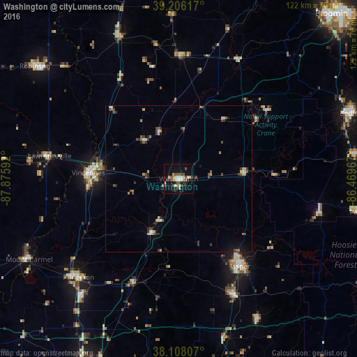
Analysis of Washington night lights 2016
Square area 10x10 km:
 2.44%
2.44%90-99
4.22%80-89
3.57%70-79
0.81%60-69
2.44%50-59
5.03%40-49
3.57%30-39
4.38%20-29
4.55%10-19
19.64%0-9
49.35%Square area 50x50 km:
0.21%90-99
0.34%80-89
0.52%70-79
0.26%60-69
0.37%50-59
0.61%40-49
0.66%30-39
0.72%20-29
0.52%10-19
1.56%0-9
94.22%Clear (daylight) street map image can be seen on geolist.org.
Map coordinates:
39° 12' 22.2" North, 87° 52' 33.3" West
38° 39' 33.2" North, 87° 10' 22" West
38° 6' 29.1" North, 86° 28' 10.8" West
Some cities around Washington sort by population:
• Vincennes
31 km =19.3 mi,  273°
273°
• Jasper
36.4 km =22.6 mi,  144°
144°
• Bedford
63.5 km =39.5 mi,  69°
69°
• Princeton
48.2 km =30 mi,  225°
225°
• Robinson
62.4 km =38.8 mi,  308°
308°
• Mount Carmel
58.2 km =36.2 mi,  241°
241°
• Huntingburg
44.3 km =27.5 mi,  154°
154°
• Linton
41.8 km =26 mi,  0°
0°
4266586 (p: 12,078)
Sources (retrieved 2019-11-25):
» Earth at Night: Flat Maps 2012, 2016