Red Bluff night lights from space
Night Light of Red Bluff (California) from space (United States) Src. Average luminocity for 10x10km area is 21.5325% and for 50x50km: 1.3775%.
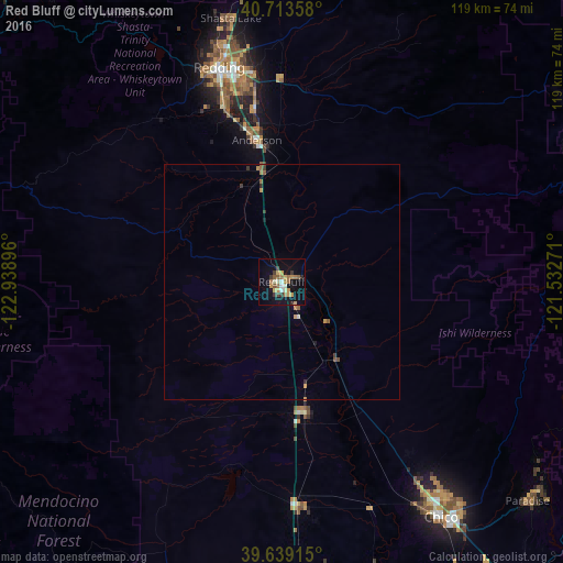
Analysis of Red Bluff night lights 2016
Square area 10x10 km:
 1.3%
1.3%90-99
1.95%80-89
1.95%70-79
6.82%60-69
4.55%50-59
2.6%40-49
0.97%30-39
4.38%20-29
0.81%10-19
18.51%0-9
56.17%Square area 50x50 km:
0.07%90-99
0.08%80-89
0.08%70-79
0.4%60-69
0.27%50-59
0.25%40-49
0.07%30-39
0.31%20-29
0.09%10-19
0.8%0-9
97.55%Clear (daylight) street map image can be seen on geolist.org.
Map coordinates:
40° 42' 48.9" North, 122° 56' 20.3" West
40° 10' 42.6" North, 122° 14' 9" West
39° 38' 20.9" North, 121° 31' 57.8" West
Some cities around Red Bluff sort by population:
• Redding
47.3 km =29.4 mi,  343°
343°
• Chico
60.5 km =37.6 mi,  145°
145°
• Magalia
69.3 km =43.1 mi,  126°
126°
• Anderson
30.4 km =18.9 mi,  350°
350°
• Shasta Lake
57 km =35.4 mi, 348°
• Orland
48.1 km =29.9 mi,  175°
175°
• Corning
28.3 km =17.6 mi,  170°
170°
• Durham
69.9 km =43.4 mi, 147°
5570065 (p: 14,131)
Sources (retrieved 2019-11-25):
» Earth at Night: Flat Maps 2012, 2016