Ranchettes night lights from space
Night Light of Ranchettes (Wyoming) from space (United States) Src. Average luminocity for 10x10km area is 19.5633% and for 50x50km: 5.566%.
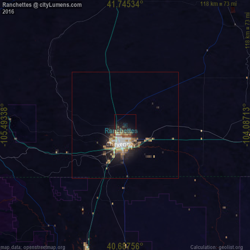
Analysis of Ranchettes night lights 2016
Square area 10x10 km:
 0.81%
0.81%90-99
0.81%80-89
3.08%70-79
1.3%60-69
3.08%50-59
4.71%40-49
3.57%30-39
8.6%20-29
6.01%10-19
18.34%0-9
49.68%Square area 50x50 km:
0.77%90-99
0.91%80-89
0.72%70-79
0.69%60-69
0.8%50-59
0.86%40-49
0.57%30-39
1.03%20-29
1.52%10-19
3.4%0-9
88.72%Clear (daylight) street map image can be seen on geolist.org.
Map coordinates:
41° 44' 43.2" North, 105° 29' 36.2" West
41° 13' 6.9" North, 104° 47' 24.9" West
40° 41' 15.2" North, 104° 5' 13.7" West
Some cities around Ranchettes sort by population:
• Fort Collins
74.6 km =46.4 mi,  199°
199°
• Greeley
88.7 km =55.1 mi,  175°
175°
• Loveland
94.4 km =58.7 mi,  194°
194°
• Cheyenne
9.1 km =5.7 mi, 196°
• Laramie
67.7 km =42.1 mi,  278°
278°
• Windsor
82.9 km =51.5 mi, 186°
• Evans
94 km =58.4 mi,  174°
174°
• Wellington
60.1 km =37.3 mi, 197°
5835956 (p: 5,798)
Sources (retrieved 2019-11-25):
» Earth at Night: Flat Maps 2012, 2016