Phoenixville night lights from space
Night Light of Phoenixville (Pennsylvania) from space (United States) Src. Average luminocity for 10x10km area is 59.7857% and for 50x50km: 51.011%.
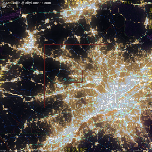
Analysis of Phoenixville night lights 2016
Square area 10x10 km:
 5.36%
5.36%90-99
5.68%80-89
14.45%70-79
6.82%60-69
7.63%50-59
25%40-49
13.96%30-39
16.88%20-29
4.22%10-19
0%0-9
0%Square area 50x50 km:
8.6%90-99
7.49%80-89
6.89%70-79
8.42%60-69
11.89%50-59
10.5%40-49
7.69%30-39
7.68%20-29
6.7%10-19
10.05%0-9
14.08%Clear (daylight) street map image can be seen on geolist.org.
Map coordinates:
40° 39' 57.1" North, 76° 13' 4.9" West
40° 7' 49.4" North, 75° 30' 53.7" West
39° 35' 26.4" North, 74° 48' 42.4" West
Some cities around Phoenixville sort by population:
• King of Prussia
11.1 km =6.9 mi,  114°
114°
• Limerick
11.2 km =7 mi,  356°
356°
• West Norriton
11.6 km =7.2 mi,  90°
90°
• Audubon
7.1 km =4.4 mi, 92°
• Chester Springs
9.5 km =5.9 mi,  245°
245°
• Trooper
9.9 km =6.2 mi,  77°
77°
• Paoli
10.4 km =6.5 mi,  161°
161°
• Collegeville
8.2 km =5.1 mi,  41°
41°
5205849 (p: 16,658)
Sources (retrieved 2019-11-25):
» Earth at Night: Flat Maps 2012, 2016