West Norriton night lights from space
Night Light of West Norriton (Pennsylvania) from space (United States) Src. Average luminocity for 10x10km area is 77.8425% and for 50x50km: 64.1134%.
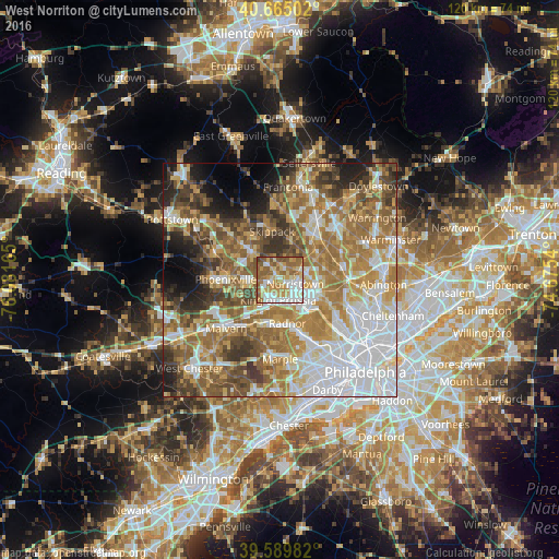
Analysis of West Norriton night lights 2016
Square area 10x10 km:
 16.72%
90-99
18.02%80-89
12.5%70-79
15.75%60-69
16.23%50-59
16.56%40-49
2.92%30-39
1.3%20-29
0%10-19
0%0-9
0%Square area 50x50 km:
16.65%90-99
10.17%80-89
8.49%70-79
10.2%60-69
14.13%50-59
10.58%40-49
7.51%30-39
6.77%20-29
5.25%10-19
5.65%0-9
4.6%Clear (daylight) street map image can be seen on geolist.org.
Map coordinates:
40° 39' 54.1" North, 76° 4' 53.9" West
40° 7' 46.4" North, 75° 22' 42.7" West
39° 35' 23.4" North, 74° 40' 31.4" West
Some cities around West Norriton sort by population:
• Norristown
3.4 km =2.1 mi,  105°
105°
• Radnor
9.4 km =5.8 mi,  170°
170°
• King of Prussia
4.7 km =2.9 mi,  198°
198°
• Audubon
4.5 km =2.8 mi,  267°
267°
• Conshohocken
8.6 km =5.3 mi,  130°
130°
• Plymouth Meeting
9.4 km =5.8 mi, 108°
• Trooper
3 km =1.9 mi,  318°
318°
• Collegeville
8.8 km =5.5 mi, 315°
5218827 (p: 14,702)
Sources (retrieved 2019-11-25):
» Earth at Night: Flat Maps 2012, 2016