Limerick night lights from space
Night Light of Limerick (Pennsylvania) from space (United States) Src. Average luminocity for 10x10km area is 49.8994% and for 50x50km: 40.4355%.
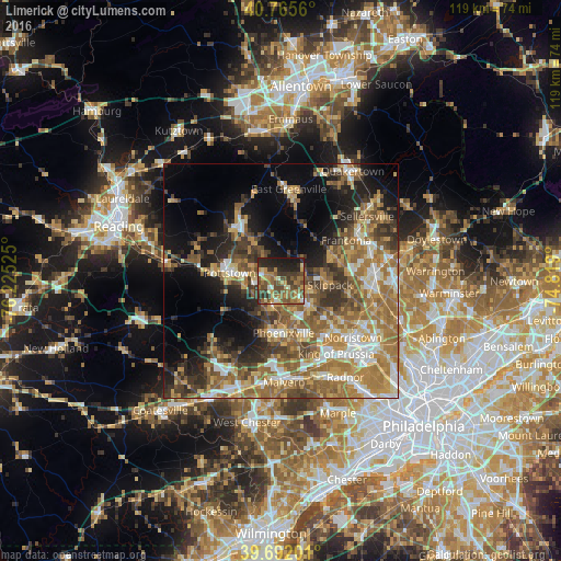
Analysis of Limerick night lights 2016
Square area 10x10 km:
 2.6%
2.6%90-99
3.57%80-89
6.66%70-79
9.9%60-69
10.39%50-59
15.42%40-49
14.61%30-39
11.85%20-29
13.96%10-19
11.04%0-9
0%Square area 50x50 km:
4.86%90-99
5.33%80-89
5.43%70-79
7.29%60-69
10.15%50-59
8.53%40-49
5.96%30-39
6.4%20-29
6.83%10-19
11.55%0-9
27.65%Clear (daylight) street map image can be seen on geolist.org.
Map coordinates:
40° 45' 56.2" North, 76° 13' 30.9" West
40° 13' 51.3" North, 75° 31' 19.6" West
39° 41' 31.2" North, 74° 49' 8.4" West
Some cities around Limerick sort by population:
• Pottstown
10.9 km =6.8 mi,  278°
278°
• Phoenixville
11.2 km =7 mi,  176°
176°
• Harleysville
12.7 km =7.9 mi,  64°
64°
• Audubon
13.8 km =8.6 mi,  146°
146°
• Sanatoga
6.4 km =4 mi, 284°
• Kulpsville
15.8 km =9.8 mi,  85°
85°
• Trooper
13.6 km =8.5 mi,  131°
131°
• Collegeville
7.8 km =4.8 mi, 130°
5198034 (p: 18,074)
Sources (retrieved 2019-11-25):
» Earth at Night: Flat Maps 2012, 2016