Collegeville night lights from space
Night Light of Collegeville (Pennsylvania) from space (United States) Src. Average luminocity for 10x10km area is 60.6964% and for 50x50km: 51.6472%.
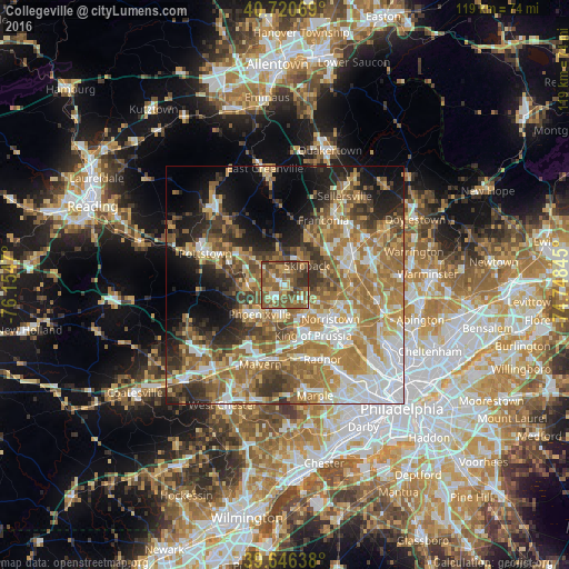
Analysis of Collegeville night lights 2016
Square area 10x10 km:
 4.55%
4.55%90-99
4.22%80-89
10.06%70-79
10.55%60-69
12.82%50-59
31.33%40-49
13.96%30-39
11.2%20-29
1.3%10-19
0%0-9
0%Square area 50x50 km:
8.79%90-99
7.75%80-89
7.33%70-79
9.01%60-69
12.51%50-59
9.77%40-49
6.68%30-39
6.89%20-29
7.04%10-19
9.86%0-9
14.38%Clear (daylight) street map image can be seen on geolist.org.
Map coordinates:
40° 43' 14.5" North, 76° 9' 16.9" West
40° 11' 8.4" North, 75° 27' 5.7" West
39° 38' 47" North, 74° 44' 54.4" West
Some cities around Collegeville sort by population:
• King of Prussia
11.7 km =7.3 mi,  156°
156°
• Limerick
7.8 km =4.8 mi,  310°
310°
• Phoenixville
8.2 km =5.1 mi,  221°
221°
• West Norriton
8.8 km =5.5 mi,  135°
135°
• Harleysville
11.8 km =7.3 mi,  27°
27°
• Audubon
6.6 km =4.1 mi,  165°
165°
• Kulpsville
11.7 km =7.3 mi,  56°
56°
• Trooper
5.8 km =3.6 mi,  133°
133°
5184966 (p: 5,287)
Sources (retrieved 2019-11-25):
» Earth at Night: Flat Maps 2012, 2016