Audubon night lights from space
Night Light of Audubon (Pennsylvania) from space (United States) Src. Average luminocity for 10x10km area is 71.5097% and for 50x50km: 60.0269%.
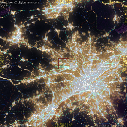
Analysis of Audubon night lights 2016
Square area 10x10 km:
 12.18%
90-99
11.2%80-89
15.26%70-79
10.55%60-69
13.96%50-59
26.14%40-49
9.42%30-39
1.3%20-29
0%10-19
0%0-9
0%Square area 50x50 km:
14.08%90-99
8.96%80-89
8.07%70-79
9.76%60-69
13.49%50-59
10.74%40-49
7.59%30-39
6.94%20-29
6.1%10-19
7.77%0-9
6.5%Clear (daylight) street map image can be seen on geolist.org.
Map coordinates:
40° 39' 48.1" North, 76° 8' 5.9" West
40° 7' 40.4" North, 75° 25' 54.7" West
39° 35' 17.3" North, 74° 43' 43.4" West
Some cities around Audubon sort by population:
• Norristown
7.8 km =4.8 mi,  95°
95°
• Wayne
10.1 km =6.3 mi,  158°
158°
• King of Prussia
5.3 km =3.3 mi,  144°
144°
• Phoenixville
7.1 km =4.4 mi,  272°
272°
• West Norriton
4.5 km =2.8 mi,  87°
87°
• Trooper
3.5 km =2.2 mi,  46°
46°
• Paoli
10.3 km =6.4 mi,  201°
201°
• Collegeville
6.6 km =4.1 mi,  345°
345°
5178686 (p: 8,433)
Sources (retrieved 2019-11-25):
» Earth at Night: Flat Maps 2012, 2016